



Weather Headlines:
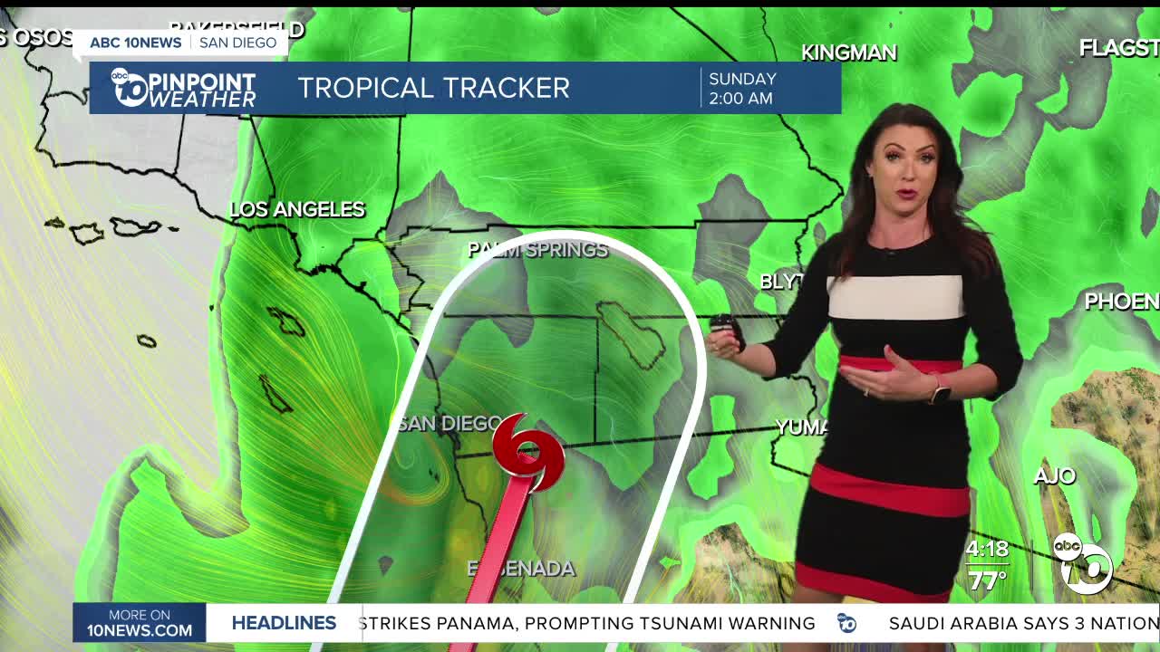
- Tropical Storm Rachel brings flooding rain, damaging winds and significant coastal flooding and beach erosion this weekend.
- Greatest impacts are expected Saturday night through Sunday afternoon, mostly likely early Sunday morning.
- Exact timing and impacts will depend on where Rachel actually tracks, but San Diego is right in the middle of the path of uncertainty
- Tropical Storm Watch in effect until further notice
- Damaging winds possible late Saturday night into Sunday afternoon, peaking early Sunday morning
- Flood Watch in effect from 11pm Saturday until 8pm Sunday
- Coastal Flood Warning in effect until 3pm Sunday, then a Coastal Flood Advisory from 3pm Sunday until 2pm Tuesday
- Beach Hazards Statement in effect from 6am to 11pm Sunday
- A second storm from the Pacific will continue scattered showers Monday into Tuesday morning, but impacts will be minimal.
Tropical Storm Rachel is headed straight towards San Diego and is likely going to bring big waves, coastal flooding, heavy rain, possible flash flooding, damaging winds, and thunderstorms.
The greatest impacts are likely late Saturday night into Sunday afternoon, with the most likely timing of the heaviest rain and strongest winds early Sunday morning. Where Rachel actually tracks will determine where the worst impacts are felt.
This is a situation where you want to prepare for the worst and hope for the best.
Wind:
A Tropical Storm Watch is in effect across the county until further notice. Wind gusts of 30 to 70mph are possible anywhere in the county and sustained winds of 39mph would be a worst-case scenario. These winds will cause damage to outdoor areas and unanchored mobile homes, downed trees and power lines and broken tree-limbs. You should park your vehicle away from anything that may fall before you go to bed Saturday night. Strongest winds are expected late Saturday night into Sunday morning, though it will remain breezy to gusty through Monday.
Forecast rainfall totals through Sunday:
Rainfall totals will likely average between .40 to 1.50" for the coast and valleys, 1 to 3" in the mountains and .50 to 2" in the deserts. A Flood Watch is in effect across the county from 11pm Saturday until 8pm Sunday. The Weather Prediction Center is forecasting a 'Moderate' threat of Excessive Rainfall, which means there is a 40% chance of flooding; numerous flash floods are likely.
Peak rainfall rates of .50 to .60" per hour are possible for the coast and valleys, .70 to 1" per hour in the mountains and .50 to .70" per hour in the deserts. That's a lot of rain in a short period of time bringing the threat of flooding and flash flooding.
Coastal flooding:
Elevated surf and high tides from Tropical Storm Rachel will bring a significant threat of coastal flooding and beach erosion. A Coastal Flood Warning is in effect until 3pm Sunday, then it will be downgraded to a Coastal Flood Advisory until 2pm Tuesday for minor coastal flooding. A Beach Hazards Statement will be in effect Sunday from 6am to 11pm for waves of 5 to 9 feet and dangerous rip currents.
Storm 2:
A colder Pacific storm will bring less impactful rain Monday into Tuesday morning, with isolated to scattered light to moderate showers and breezy to gusty winds.
Rainfall totals for Monday and Tuesday will average between .10 to .25" for the coast and valleys, .25 to .50" in the mountains and up to .10" in the deserts.
It will be cooler this weekend with temperatures back near normal on Saturday, though it will be muggy. Temperatures plummet anywhere from 20 to 40 degrees from the heat we've been feeling this week by Monday as a colder Pacific storm moves into Southern California.
This weekend you can expect 70s at the coast, 80s inland on Saturday dropping to the 70s on Sunday, 70s in the mountains on Saturday dropping to the 60s and 50s Sunday into next week, and 90s in the deserts Saturday, 80s on Sunday and 70s on Monday. These temperatures will be 5 to 20 degrees below average, a stark difference from the 20 to 30-degree above-normal temperatures we felt this week!
Sunshine returns by Tuesday afternoon and a warm-up with follow the rest of the week. Santa Ana winds are expected by the end of next week into the weekend bumping temperatures back into the 80s at the cosat and possible 90s inland. Luckily the rain we see will help mitigate the fire danger, though this rain may be too much of a good thing.
Saturday's Highs:
Coast: 73-80°
Inland:78-86°
Mountains: 70-83°
Deserts: 93-96°
Follow ABC 10News Chief Meteorologist Megan Parry on Facebook at Megan Parry 10News, Instagram @mis_meg_wx and Twitter @10NewsParry.
