


Weather Headlines:
- Dangerous heat continues through Friday with highs 10 to 20 degrees above average.
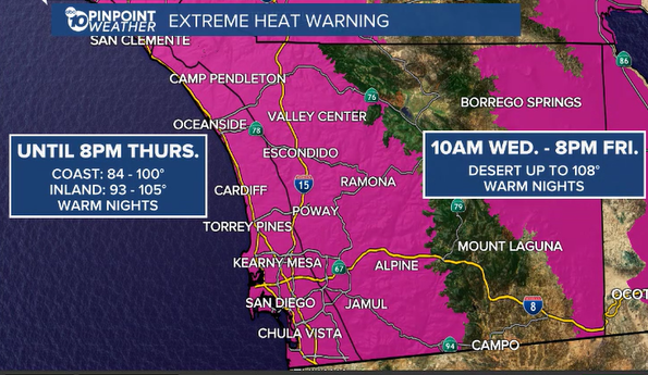
- Extreme Heat Warning for the coast and valleys until 8pm Thursday and for the deserts from Wednesday through Friday.
- Above-normal temperatures last through Saturday but drop a few degrees each day.
- Elevated surf and high tides may bring coastal flooding and beach erosion through Friday.
- 10 to 30 degrees cooler this weekend into early next week with a chance of showers Sunday through Tuesday.
Tuesday was another record-hot day with widespread 90s and 100s for the coast and valleys.
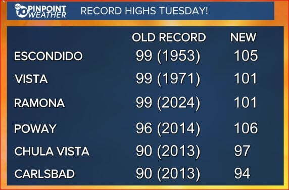
The extreme heat continues for a few more days with temperatures trending 10 to 20 degrees above average across the county. Temperatures will drop a few degrees each day but will remain above average through Saturday with greater cooling Sunday into early next week.
An Extreme Heat Warning continues for the coast and valleys until 8pm Thursday while a new Extreme Heat Warning begins in the deserts at 10am Wednesday until 8pm Friday.
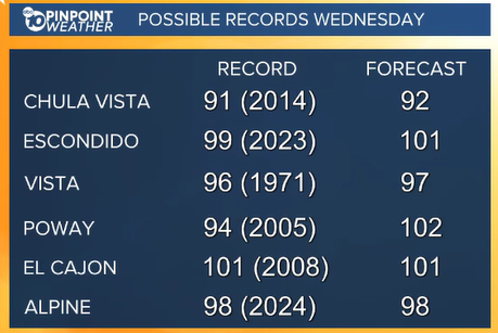
I'm forecasting several more record highs on Wednesday:
By Thursday we'll see more 90s and fewer 100s inland and more 80s and fewer 90s at the coast, though this is still 10 to 17 degrees above average.
It will be much cooler this weekend as a storm to the north pushes the high-pressure heat dome out of the west. Temperatures will plummet 10 to 30 degrees this weekend into next week when we'll see 70s return to the coast, 80s and even 70s inland, 70s and 60s in the mountains and 90s and 80s in the deserts.
That storm will steer the jet stream south, acting to pull up moisture from tropical cyclone Rachel which will bring us a chance of showers Sunday through Tuesday. The chance of rain depends on several factors, including how far south the jet stream dives and if that moisture is able to get pulled into Southern California so stay with the Pinpoint Weather Team for updates.
Elevated surf from Hurricane Rachel and high tides may lead to coastal flooding and beach erosion. A Beach Hazards Statement is in effect until 11pm Friday for waves of 3 to 6 feet and strong rip currents. A Coastal Flood Advisory will also be in effect from 6am Wednesday until 11am Friday for possible issues during the morning and evening high tides between 6.5 to 7 feet.
Tips to Stay Safe in the Heat: Extreme heat is a danger to anyone, especially those with respiratory issues, people who work outdoors, children and the elderly. Make sure outdoor pets have safe shelter and cool water. Cars turn into ovens in a matter of minutes so be sure to check the back seat and never leave children or pets in the car. Wear light-weight, light-colored, loose-fitting clothing and stay hydrated! Avoid strenuous outdoor activities, enjoy air conditioning whenever possible and if you're working in the heat make sure to take breaks often and drink plenty of water.
Now is a good time to check your cars for loose tire tread or parts—anything that could easily spark a fire. In addition, make sure you have a go bag and working flashlights in case of an emergency or power outage. Also, prune and trim trees and shrubs to make a defensible space around your home.
Tips to make a fire plan: Figure out where you will go and who you need to contact. Grab important documents and medications for your family and your pets. Bring toys and food for kids and pets. Decide what you are willing to leave and what needs to come.
Wednesday's Highs:
Coast: 85-97°
Inland: 96-102°
Mountains: 83-97°
Deserts: 103-107°
Follow ABC 10News Chief Meteorologist Megan Parry on Facebook at Megan Parry 10News, Instagram @mis_meg_wx and Twitter @10NewsParry.
