

A third round of heavy rain, strong winds and thunderstorms ended early Wednesday morning, with isolated showers during the day, gusty winds and chilly temperatures.
One more round of wet and windy weather arrives on Thursday, and this storm will produce more rain during the day than in the early morning hours, like the last two storms. Isolated showers in the morning, becoming scattered by late morning into the afternoon with a chance of thunderstorms. A few showers linger through early Friday morning before drying out and warming up for the weekend.
Impressive rainfall totals so far with most areas receiving 1 to 3 inches, locally over 5 inches. While Mt. Laguna has reported over 5 inches of snow as of Wednesday morning.
Click here to see real-time rain totals where you live.
Additional rainfall through Thursday will average between 0.20 and 0.50" from the coast to the mountains and between .05 to .25 in the deserts. Localized flooding remains a concern.
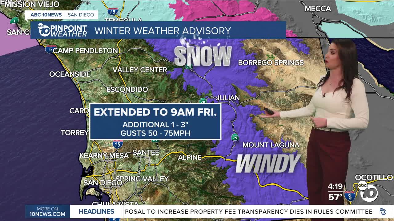
The Winter Weather Advisory for the mountains has been extended until 9am Friday. Additional snow of 1 to 3" is possible, mainly above 4,500 feet, but we may see a dusting in Julian, which is at 4,240 feet. Snow levels will hover between 4,000 and 5,000 feet through Friday morning, potentially even as low as 3,500 feet.
If headed to the mountains, be sure to bring chains and extra supplies. Be respectful of the people who live there and pack up your trash and bring it home with you.
A new Wind Advisory for the coast and valleys will be in effect from 9am Thursday to 2am Friday for southwesterly winds of 15 to 25mph, gusts 30 to 45mph.
A Wind Advisory has been extended in the deserts until 9am Friday for westerly winds of 35 to 45mph and gusts of 50 to 65mph.
These winds, coupled with saturated ground from the rain, pose a risk of downed trees and tree limbs and possible power outages. Pay attention to your surroundings and don't park your vehicle near trees that may fall.
A High Surf Advisory is in effect until 10pm Friday for waves of 5 to 9 feet, sets to 11 feet, dangerous rip currents, and possible minor coastal flooding.
Things dry out just in time for the weekend and it will be warmer in the mid to upper 60s at the coast, mid 60s to low 70s inland, 50s in the mountains and 70s in the deserts.
There is a slight chance of showers mid to late next week, but there remains high uncertainty on these storms, so stay with the Pinpoint Weather Team, San Diego's Most Accurate Forecast, for updates on this active storm track.
Thursday's Highs:
Coast: 57-60°
Inland: 52-59°
Mountains: 34-49°
Deserts: 62-66°
Follow ABC 10News Meteorologist Megan Parry on Facebook at Megan Parry 10News, Instagram @mis_meg_wx and Twitter @10NewsParry.
