

A second storm will pass south of San Diego through Friday, bringing patchy drizzle in the morning for the coast and valleys and a slight chance of showers in the afternoon near the mountains.
Click here to see rainfall totals where you live.
Drier with sunshine returning Saturday for Valentine's Day and slightly warmer temperatures, in the 60s for the coast, upper-60s to low-70s inland, 50s in the mountains, and 70s in the deserts.
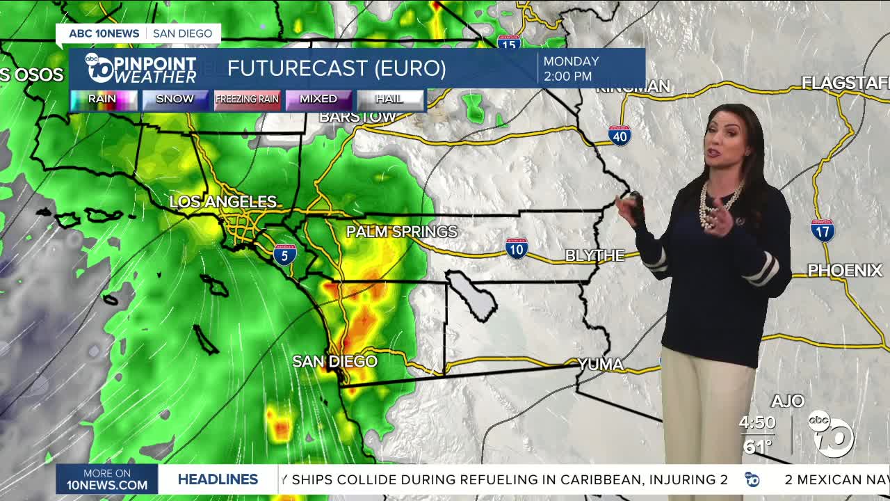
The strongest storm of the season is likely next week, bringing widespread rain, strong winds, a slight chance of thunderstorms, and mountain snow.
Monday will be a high-impact day, followed by Tuesday with a second storm keeping the wet weather going through at least Thursday. Expect steady, heavy rain leading to a flood threat.
Preliminary forecast totals from Monday through Wednesday will average between .50 to 2" for the coast and valleys, 1 to 3" in the mountains, and .25 to 1" in the deserts.
Additional rainfall through Thursday with the second storm expected between .30 to 1.25" for the coast and valleys, .50 to 2" in the mountains and .10 to .40" in the deserts.
Flooding will be a threat next week and if you live in an area that has flood in the past, you should get sandbags ready and this weekend lift any valuables off the ground. During this week's rain, if you noticed you need new tires or windshield wipers, now is the time to get those. Also, check your roof for leaks and clear gutters if needed.
Early snow level forecast expected to start between 6,000 to 6,500' Monday, dropping to 5,000 to 5,000' Tuesday and potentially between 4,000 and 4,500' Wednesday. This will most likely be a rain event for Julian, but if snow levels do drop to 4,000', we may see a dusting there, while the higher mountains will likely pick up between 1 to 3 inches; however, that depends on where snow levels actually end up.
Wind will also be a major threat of these storms next week. Southerly winds will build Monday morning, turning westerly by the afternoon. Preliminary wind forecast is for gusts of 25 to 40mph for the coast and valleys and 30 to 60mph for the mountains and deserts.
There are more chances of rain as we continue further into February, so stay with the Pinpoint Weather Team, San Diego's Most Accurate Forecast, for updates on this active storm track.
Friday's Highs:
Coast: 63-68°
Inland: 67-71°
Mountains: 52-64°
Deserts: 74-77°
Follow ABC 10News Meteorologist Megan Parry on Facebook at Megan Parry 10News, Instagram @mis_meg_wx and Twitter @10NewsParry.
