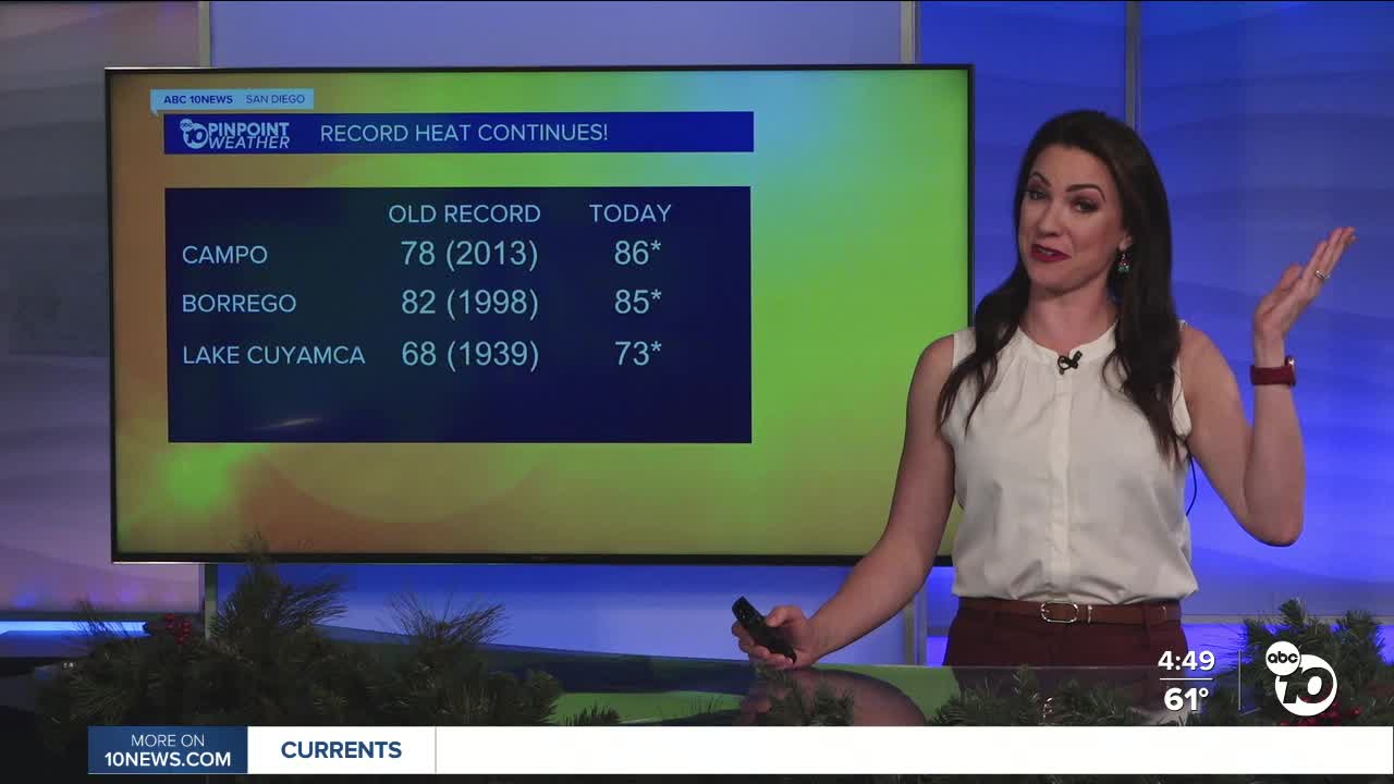


The mountains and deserts had a record hot day Tuesday! Borrego Springs (85°), Campo (86°) and Lake Cuyamaca (73°) all set record highs while Palomar Mountain didn't report, it may have set a record, but we'll never know!
Tomorrow the only record I'm forecasting is at Palomar Mountain at 68° but we'll be a degree shy in Campo at 80°, so it's possible there, we'll also be close again in Borrego Springs.
Temperatures away from the coast will be 10 to 20 degrees above average.
Click here to see daily record and average temperatures where you live.
Dense fog will be widespread into Wednesday morning, likely leading to a slow morning commute. A Dense Fog Advisory is in effect until 10am form the coast to 10 miles inland.
The fog will be patchier and less widespread into Thursday morning as winds turn back offshore and mild Santa Winds develop.
It will be warm by Thursday and Friday by 4 to 10 degrees for the coast and valleys, with little change in the mountains and deserts, where highs will remain near record levels. In fact, Borrego Springs and Palomar Mountain will be close to record highs through the weekend! Some inland areas, like Ramona and Alpine, may set record highs Thursday and Friday.
Thursday and Friday will be the warmest days of the week for most of the county, with 70s and 80s.
Temperatures cool over the weekend, but remain mostly 5 to 15 degrees above average away from the coast. This weekend we'll see 60s and 70s.
Despite these warm temperatures, winter is coming! The winter solstice happens this Sunday at 7:03am.
There are hints that we may get rain by Christmas Eve into Christmas Day, and potentially another storm before the end of the year.
Wednesday's Highs:
Coast: 62-73°
Inland: 70-79°
Mountains: 66-80°
Deserts: 82-85°
Follow ABC 10News Meteorologist Megan Parry on Facebook at Megan Parry 10News, Instagram @mis_meg_wx and Twitter @10NewsParry.
