

It was the third consecutive day of record heat! Daily record highs were set in Escondido (86°), Borrego Springs (85°) and Lake Cuyamaca (71°) while Ramona tied their record high of 82°.
Not only are the afternoon high temperatures impressive, but the huge temperature swings from the morning lows are also impressive. The San Pasquel Valley warmed from 36° this morning to 86° this afternoon, a 50° jump, while Ramona warmed from 36° to 82°, a 46° change!
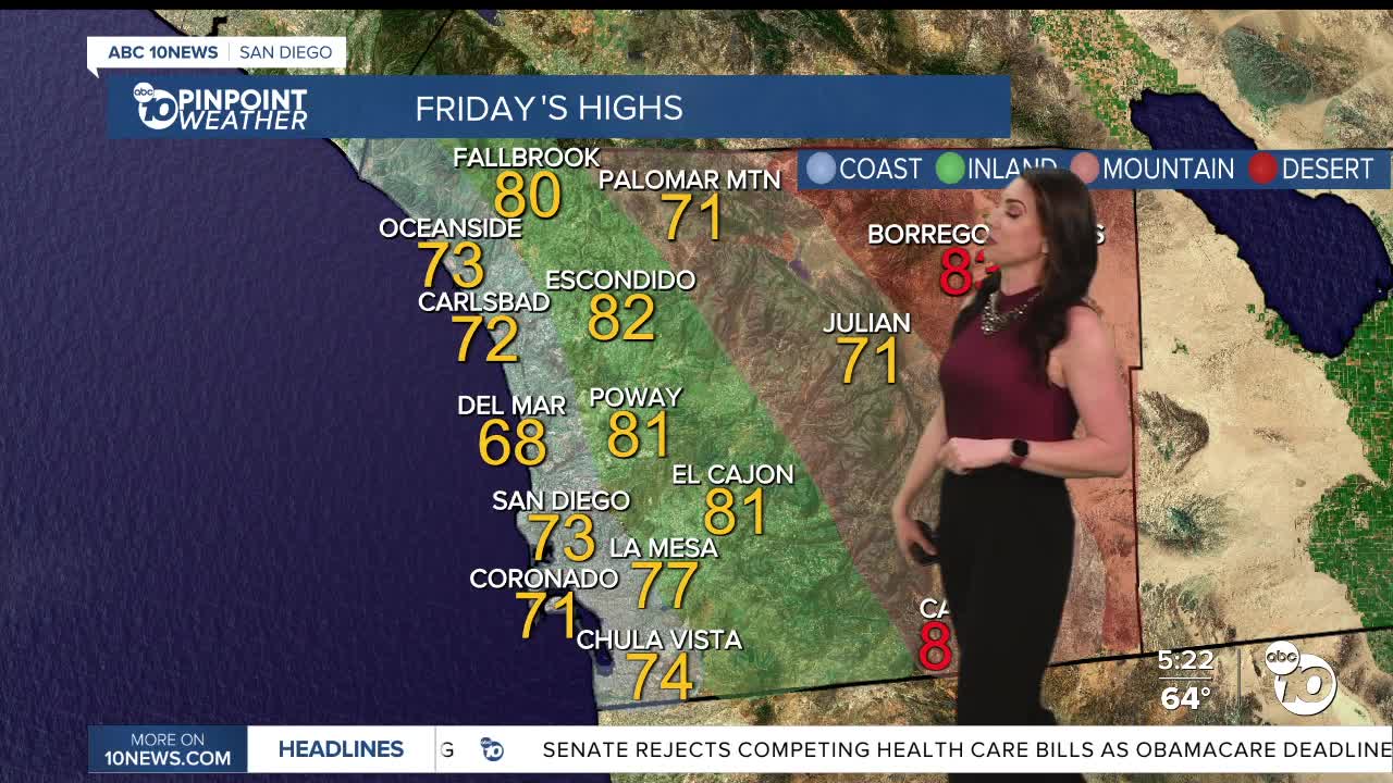
The mountains and deserts will be just as warm on Friday, while it will be several degrees cooler along the coast and in the valleys as the sea-breeze strengthens and patchy low clouds and fog return. Despite the drop in temperatures, highs will remain 7 to 21 degrees above average. I'm forecasting record highs in Campo (81) and Borrego Springs (83).
While we cool slightly by the weekend, temperatures will remain well above average. This weekend you can expect highs in the upper-60s to mid-70s at the coast, which is 5 to 10 degrees warmer than normal, while inland areas will be in the mid-70s to low-80s which is 10 to 15 degrees above average, mid to upper-60s in the mountains, which is 15 to 20 degrees above normal and low-80s in the desert is 10 to 15 degrees above average.
The marine layer returns by Friday morning, when we may see patchy dense fog, especially near the coast. Patchy fog may impact the Friday morning commute with low clouds and fog spreading farther inland into the weekend.
High clouds will build by Friday afternoon with mostly sunny to partly cloudy skies into Saturday.
Mild Santa Ana winds return Monday, bumping up temperatures and wind while dropping humidity. We'll see 70s and a few 60s along the coast into next week, with 70s and 80s inland, 60s and a few 70s in the mountains and 70s and 80s in the deserts.
Friday's Highs:
Coast: 68-75°
Inland: 64-83°
Mountains: 66-81
Deserts: 82-84°
Follow ABC 10News Meteorologist Megan Parry on Facebook at Megan Parry 10News, Instagram @mis_meg_wx and Twitter @10NewsParry.
