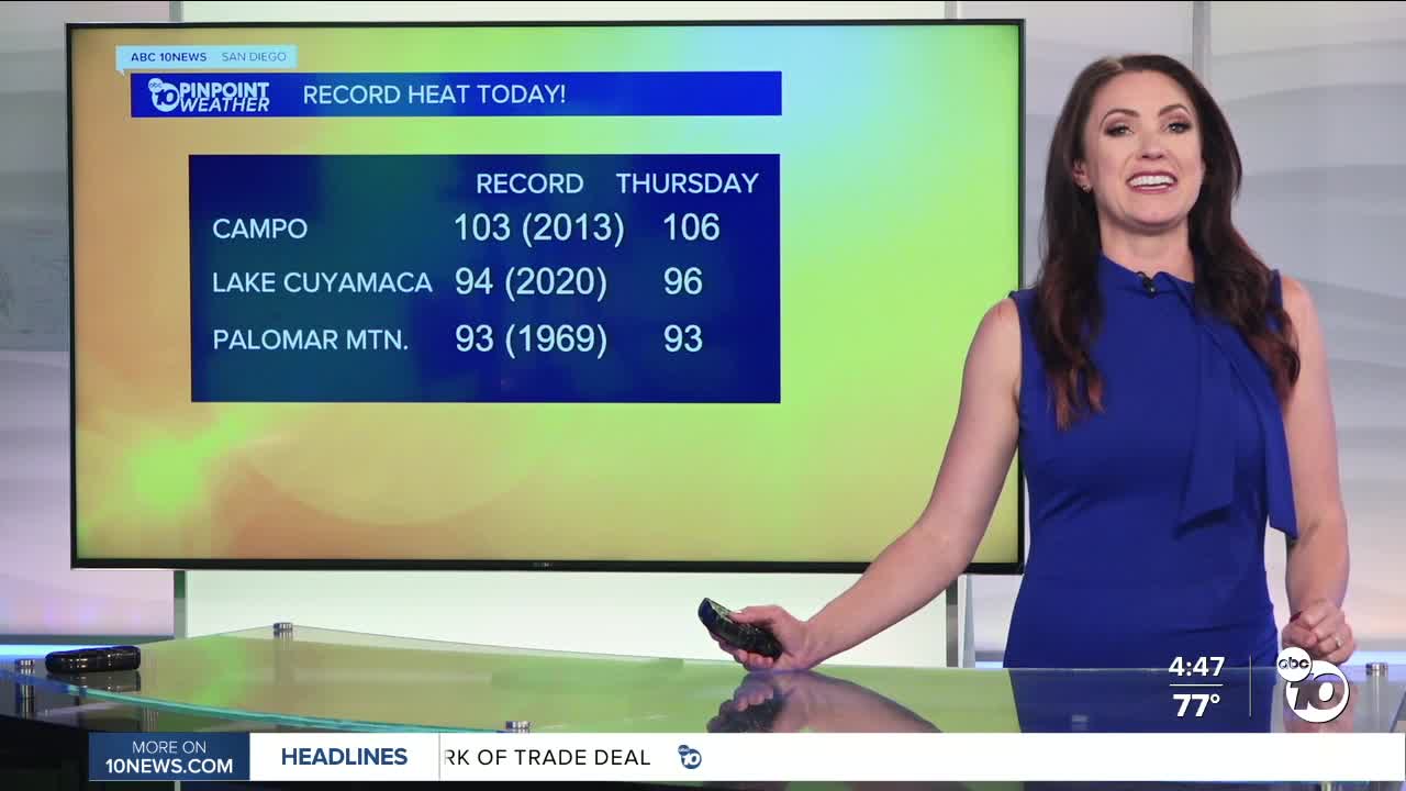


Today was a record hot day! Campo soared to 106 degrees, breaking the previous daily record high of 103 from 2013, Lake Cuyamaca at 96, breaking the 2020 record of 94, and Palomar Mountain tied its record high of 93 from 1969.
Tomorrow will be as hot or even a touch hotter than today, but also more humid, making things feel more uncomfortable. High pressure continues to expand west, which will ramp up the heat as well as pull in monsoon moisture, bringing a chance of showers and thunderstorms starting tomorrow.
A Heat Advisory is in effect until 8pm Friday for the inland and mountain communities. Expect high temperatures between 90 and 104 degrees and warm overnight temperatures, only dropping between 68 and 76 degrees by sunrise. This may get extended at least through Saturday, maybe even Sunday.
An Extreme Heat Warning is in effect in the deserts until 8pm Saturday for high temperatures between 110 and 116 degrees and sunrise temperatures warm, between 88 and 93 degrees.
Friday there is a slight chance of showers and thunderstorms over the mountains and deserts. The chance increases over the weekend when we'll likely see isolated storms form over the mountains and a slight chance for any storms in the deserts or for storms to spill over into the valleys.
There will be so much moisture in the atmosphere that even the coast could see sprinkles to a few showers. Decreasing chance of storms Monday but latest forecast models show a possible surge of moisture Tuesday and potentially Wednesday which could bring more widespread storms to parts of the county. Confidence remains low this far out and will be something the Pinpoint Weather Team will be tracking through the weekend.
The heat peaks through Friday with high temperatures up to 10 degrees above normal, while morning low temperatures will be up to 15 degrees above normal. The heat risk will be elevated not only due to the high afternoon temperatures but also because of the lack of relief overnight.
Temperatures drop back near average by Monday with greater cooling by midweek and more comfortable humidity levels by the end of the week.
Friday's Highs:
Coast: 76-89°
Inland: 90-101°
Mountains: 89-104°
Deserts: 113-116°
Follow ABC 10News Meteorologist Megan Parry on Facebook at Megan Parry 10News, Instagram @mis_meg_wx and Twitter @10NewsParry.
