

It was warmer today, though temperatures are trending close to average across the county. The heat ramps up tomorrow as high pressure expands west, while humidity builds Thursday, becoming more humid by the weekend as monsoon moisture surges in.
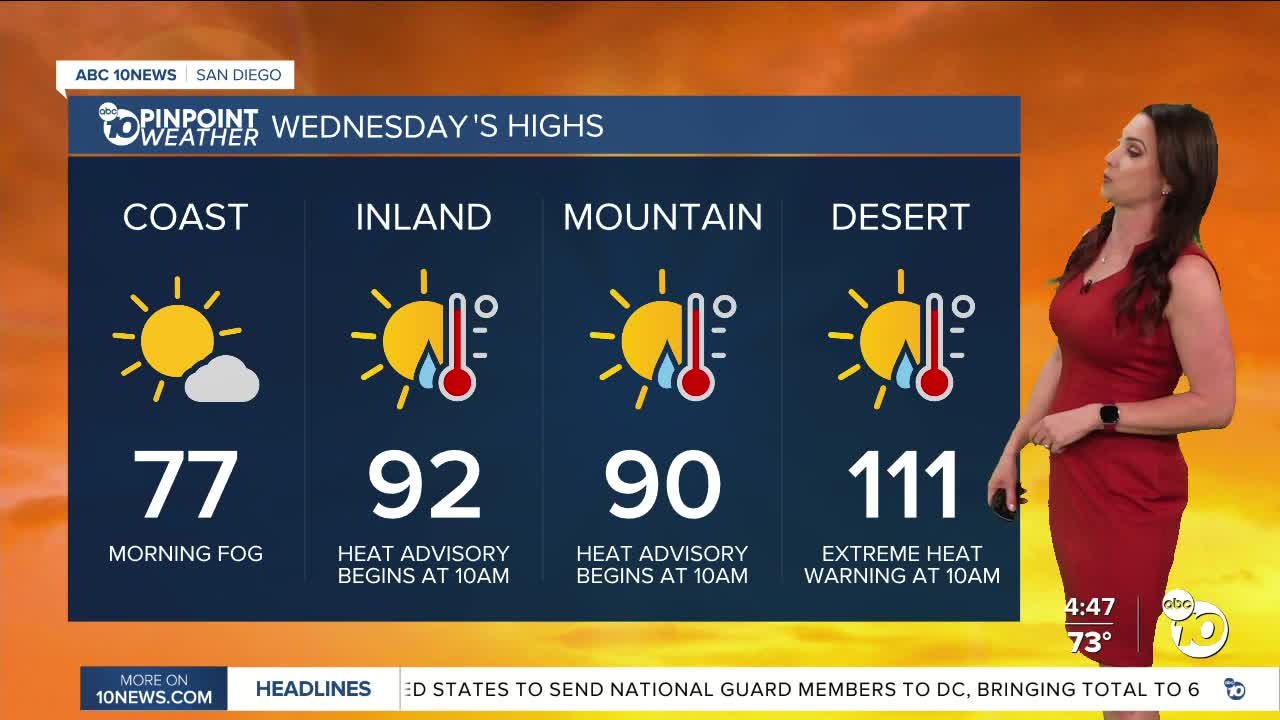
A Heat Advisory will be in effect from 10am Wednesday until 8pm Friday for the inland and mountain communities. Expect high temperatures between 90 and 102 degrees and warm overnight temperatures only dropping between 68 to 76 degrees by sunrise.
An Extreme Heat Warning begins at 10am in the deserts and lasts until 8pm Saturday for high temperatures between 110 and 116 degrees and sunrise temperatures warm, between 88 and 93 degrees.
The marine layer will be confined to the coast tomorrow and may produce areas of fog for the commute. The marine layer will shrink by the end of the week and will remain offshore by the weekend.
Friday there is a slight chance of showers and thunderstorms over the mountains. The chance increases over the weekend when we'll likely see isolated storms form over the mountains and a slight chance for any storms in the deserts or for storms to spill over into the valleys. There will be so much moisture in the atmosphere that even the coast could see sprinkles to a few showers. A slight chance for storms continues into Monday, with the chance tapering off beyond Tuesday as monsoon flow begins to weaken.
The heat peaks Thursday and Friday with high temperatures up to 10 degrees above normal, while morning low temperatures will be up to 15 degrees above normal. The heat risk will be elevated not only due to the high afternoon temperatures but also because of the lack of relief overnight.
Temperatures drop back near average next week and humidity will be more comfortable by midweek.
Wednesday's Highs:
Coast: 73-84°
Inland: 88-96°
Mountains: 87-99°
Deserts: 110-114°
Follow ABC 10News Meteorologist Megan Parry on Facebook at Megan Parry 10News, Instagram @mis_meg_wx and Twitter @10NewsParry.
