

Cloudy conditions kicked off this holiday week, and an atmospheric river will end it.
Looking ahead toward Tuesday, we begin to see the storm move into San Diego county.
Chances will be picking up in the afternoon, and they are just getting started.
Our Flood Watch and Wind Advisory kick in overnight into Wednesday.
All of San Diego County will be under a Flood Watch on Christmas Eve, from 4 a.m. Wednesday through 1 a.m. Thursday.
The heavy rain could also cause flooding and debris flow in burn scarred areas, bringing much of southern California under a Flood watch around the same time.
We will see rainfall continue throughout Christmas Day, and pick back up again on Friday.
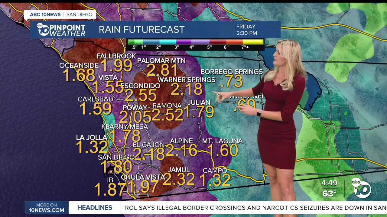
Totals and timing still have slight uncertainty, however after this storm is said and done- by Friday, most of the county should see at least 1.5 inches of rain.
Some spots in the mountains and North County could even get 2-3 inches.
Chances wind down by the weekend.
We saw lots of airport delays due to fog the past few days, but if you want to check for any flights affected by this next system, click here.
We will see temperatures hover in the mid to upper 60s throughout our coastal and inland spots Tuesday.
Mountains will be in the mid 50s, while our deserts will be close to the 70° mark.
Breezy conditions pick up Tuesday afternoon, and the Wind Advisory will be in effect for spots west of the mountains from 3 a.m. to 10 p.m. on Wednesday.
Gusts could get around 30 to 40 m.p.h. for coastal and inland valleys, with potential to reach 60 m.p.h. in the mountains.
Merry Christmas, and if you're taking to the skies, roads, or tracks- safe travels!
Tuesday's Highs:
Coast: 64-67°
Inland: 65-69°
Mountains: 55-61°
Deserts: 67-72°
Follow ABC 10News Weather Anchor Ava Kershner on Instagram, Facebook, and X.
