

SAN DIEGO (KGTV) — As we move through the next several days, Southern California stays in an active weather pattern.
We're dealing with off-and-on shower chances through the middle of next week, with the wettest period coming this weekend. After that, we do see signs of drier and warmer weather returning by the end of the week.
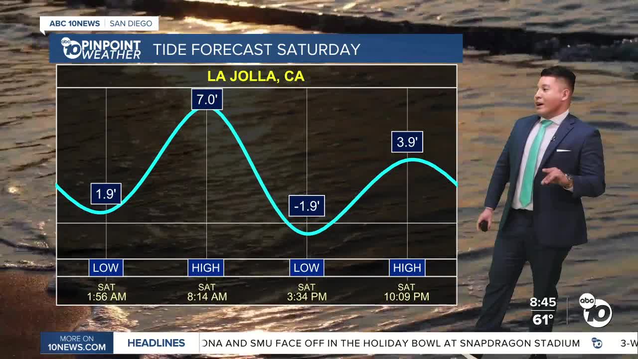
At the same time, this active pattern is lining up with king tides, which means coastal impacts will be a concern — even when the rain is light. The highest high tides will be this morning at 8:14 a.m. If you want to go out tide pooling, the low tide will be at 3:30 this afternoon.
Those king tides are prompting a Beach Hazard Statement because this can lead to coastal flooding in low-lying areas, beach erosion, and water reaching farther up the shore than you'd expect. So use caution near jetties, rocks, and low-lying coastal paths, especially around high tide.
You can see a large weather system approaching from the Pacific on satellite and radar. Ahead of it, low clouds have been filling in along the coast and into some inland areas, with patchy drizzle and light showers already showing up west of the mountains.
As we roll the forecast forward, the main band of rain moves in later today and through the evening, bringing a steadier round of showers.
Winds will also pick up as this system moves through — especially in the mountains, deserts, and through passes like Cajon Pass, where driving could become more difficult at times.
Behind this system, showers turn more hit-or-miss into Sunday, then gradually taper off into Monday morning. After that, we continue with periodic shower chances as additional weak disturbances move through.
Right now, conditions are cloudy in many areas with some patchy fog and low ceilings near the coast. Visibility has been improving, but roads may still be damp or slick from drizzle and light rain. Temperatures today are a little cooler than yesterday and will trend cooler still over the weekend.
Looking at rain chances over the next seven days — we have isolated light showers tonight and tomorrow, with the best chance for more widespread rain from late today through Saturday night and into Sunday. Rain chances linger into early next week before dropping off by Thursday.
Rain totals for most coastal and inland areas will generally be around a half inch through the weekend, with locally higher amounts in the foothills and mountains. The San Bernardino Mountains could see much higher totals — up to around 2 inches in spots — which is important given recent heavy rain and saturated soils.
