



Tropical Storm Rachel was downgraded to a Post-Tropical Cyclone around 8 p.m.
Just because the label downgraded doesn't mean the expected activity will diminish.
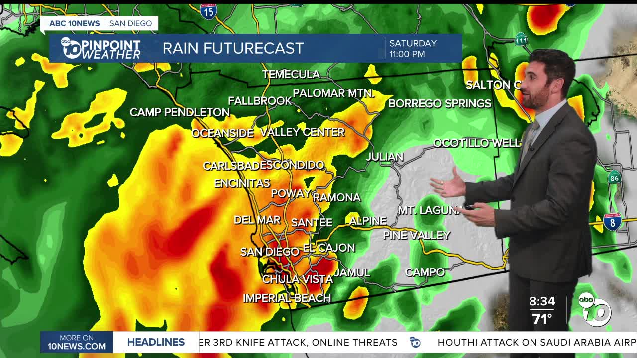
The county is still threatened by flooding, strong winds and heavy rain, with the bulk of that activity peaking late Saturday through early Sunday afternoon.
Rachel is expected to make landfall on Baja California around 11p Saturday night, just south of the US/Mexico Border.
There are several Watches/Warnings in effect over the next few days:
- Coastal Flood Warning (until 3p Sunday)
- Coastal Flood Advisory (3p Sunday through 2p Tuesday)
- Beach Hazards Statement (Sunday morning through Sunday evening)
- Tropical Storm Watch (all county, through 2p Tuesday)
- Flood Watch (all county (11p Saturday through Sunday evening)
- Flood Advisory (San Diego River at Fashion Valley, Sunday afternoon)
The heaviest rain will begin around 10:30p Saturday night, with the heaviest amounts falling in the mountains. Thunderstorms have already hit the region and more could be on the way.
Current forecast has rainfall totals of 0.50 to 1.25 inches for the coast, valleys, and deserts and 1 to 2.5 inches for the mountains.
Areas of flash and urban flooding are probable, especially where the maximum rainfall rates occur. The San Diego River at Fashion Valley is currently forecast to peak at 8.0 feet (action/monitor stage) just before noon on Sunday. Those with interests near the San Diego River should continue to monitor the forecast.
Increased winds are expected with the onset and passage of Tropical Storm Rachel.
Based on the current track, more southern and eastern parts of San Diego County are most likely to see winds around 40+ mph.
Strong sustained winds and wind gusts can be expected on Sunday. Winds will likely be enhanced by local terrain with gusts 40 to 55 mph on the desert slopes of the mountains and into the deserts. Local gusts up to 60 mph are possible on mountain ridges and in passes and canyons.
Winds are expected to remain elevated in Rachel's wake with continued strong gusts on the desert mountain slopes into the deserts through Monday morning.
Meantime, temperatures for Sunday will be 5-15 degrees below average.
After rain lingers through Monday, temperatures skies will gradually clear and temperatures gradually increase.
Areas on the coast and inland will be back to 90 degrees by Friday.
Sunday's Highs:
Coast: 68-74°
Inland: 65-74°
Mountains: 55-64°
Deserts: 71-79°
Follow ABC 10News Weather Anchor Max Goldwasser on Instagram, Facebook and Twitter.
