
(KGTV) - The Thomas Fire has scorched tens of thousands of acres in Ventura County, evacuating nearby residents from their homes.
The Ventura County Sheriff's Department has published a map of the Thomas Fire's coverage and the evacuation zones in effect.
RELATED COVERAGE:
- Cal Fire adding additional resources amid fire threat in San Diego County
- Wildfires burning in Ventura, Los Angeles Counties: What we know
- Thomas Fire in Ventura County continues to burn out of control
- Brush fire north of Los Angeles forces evacuations
HOW TO USE THE INTERACTIVE MAP
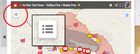 To activate ICONS INFO TAB click on the menu icon
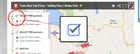 To turn off features, uncheck items in the list
